-
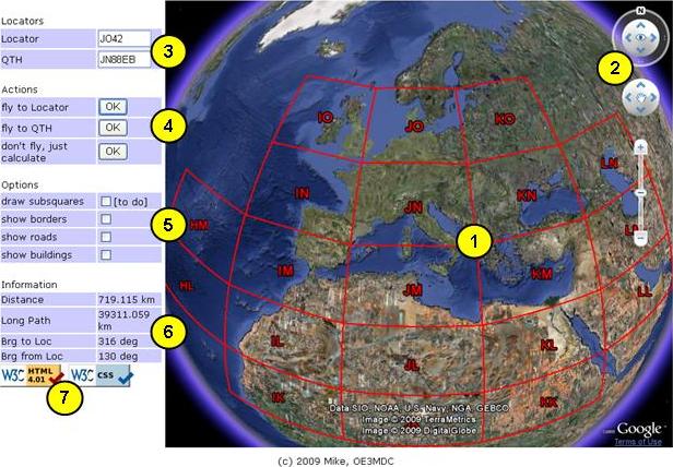
A dynamic Maidenhead Locator grid is displayed, showing fields and squares. The more you zoom in, the more details will be displayed. The predefined grid covers fields and squares (4-digit locator).
-
Use the navigation controls just like in the standard Google Earth application.
-
Enter the locator you want to look up or fly to as 2, 4, or 6 digit locator, A right click on the earth will transfer the current location into the [Locator] text box. Optionally enter your own QTH as 6 digit locator to enable calculation of distances and bearings.
Upon page unload Locator, QTH and options are saved as a cookie on your machine and will be retrieved the next time you access the page.
-
Click on the buttons to fly to locator or your QTH square, or just to calculate distances and bearings without changing the earth display.
-
Click the check boxes to display or hide some optional informations.
Subsquares are dynamically drawn as you fly there. Only one subsquare is visible at the same time.
You may ask why it doesn't work the same way with subsquares as with squares and fields, i.e. why don't they just come up dynamically.
The answer is rather simple: the amount of data to load and process would be **huge**. 18x18 fields containing 10x10 squares results in 32400 individual elements contained in the predefined KMZ. This is about enough for poor Google Earth to process, and it is ca. 1MByte to download into your PC on page initialisation. Adding the subsquares would meen to pack 24x24=576 additional elements into each of 32400 squares, resulting in a KMZ of about 19GByte - no way today!
-
Distance and bearing calculations are based on a spherical model with a radius of 6371km. The long path distance is calculate as spherical circumference minus short path distance.
-
I have tried to code clean (and semantic) HTML and CSS, however I have not tried to make everything work under every circumstance with each & every browser. In particular I chose to ignore IE's inability to render pages according to the CSS specifications. You may notice strange behaviour in some IE versions if your browser window becomes small.
If you don't like it, try a browser conforming to standards like Mozilla FireFox or Google Chrome.
NOTE: At current the Opera browser does not support the Google Earth API.